
Real-time kinematic (RTK) and Networked Transport of RTCM via Internet Protocol (NTRIP) are two advanced technologies used in positioning and navigation, particularly for high-precision applications.
Accurate, up-to-date asset data is crucial for utility companies to manage and protect their assets, plan effectively, and liaise with contractors. Yet despite the widespread use of digital data collection tools, many companies still use manual, paper-based processes to transfer data from the field to the office.

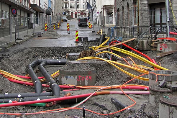
The ground under our feet is a complex network of tunnels, pipes, and cables. All of these are providing essential services, whether it's high-speed broadband internet, electricity, water, or gas. Anyone attempting any form of work must have accurate information of what and where the cables are.

Field data collection is an essential component for many field workers across multiple industries. Industries such as utilities, survey companies, airports, local governments, and others must always monitor and maintain the health of their assets. Many of these industries have assets spread across large areas, even cities, and countries. Naturally, the manual process of collecting data about every asset is challenging.

As more and more utilities turn to Collecting & GIS solutions, these products continue to evolve from primary data collection to advanced analysis tools used for operations and planning.

In the remote Chiefdom of Mpande, in north-western Zambia, Affiance Group Corp an Australian company, is developing a 10,000 hectare stevia agriculture project, titled the Northern Outgrower Project.
For two years in a row, Geolantis is the recipient of Austria’s prestigious eAward for the Smart City and Infrastructure category. This year’s winning project, “Geolantis.360 goes global: From Austria to Zimbabwe”, made from the collaboration of Geolantis GmbH, GIZ (Gesellschaft für Internationale Zusammenarbeit) and GISS (General Infrastructure Systems Solutions) made non-revenue water reduction possible, along with the digital documentation of the nation’s access to clean water.

Utility management and solutions company Geolantis wins the 2019 eAward for the category “Smart City and Infrastructure” for digitalizing records of Zimbabwe’s access to clean water, following its 2018 eAward win in the same project category.